

Dr. Garald Gordon Parker Collection - Images
Files
Download Full Text (10.2 MB)
Preview
Creation Date
1977
Time Period
circa 1977
Abstract
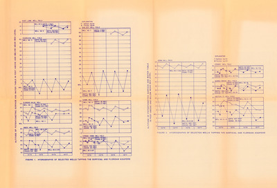
A set of line graphs or hydrographs of selected wells tapping the surficial and Floridan Aquifers. Mentioned in the charts are the East Lake Well Field, the Riverview Well Field, the Eldridge-Wilde Well, the Pasco Well Field, the Sun City Well Field, the Cosme Well Field, the Cypress Creek Well Field, the Verna Well Field, the Starkey Well Field, the Morris Bridge Well Field, and Section 21 Well Field. The line graphs have data for between 1974 and 1977.
Alt Text
A page with multiple line graphs and charts, with titles and data points visible. The graphs are organized in a grid-like format across both the left- and right-hand sides of the page. Figure 1's set of graphs are titled "Hydrographs of Selected Wells Tapping the Surficial and Floridian Aquifers" with the X axis being years and the Y axis being "Altitude of Potentiometric Surface and Water Table in Feet Above and Below Mean Sea Level." Figure 2's set of graphs are titled "Hydrographs of Selected Wells Tapping the Surficial and Florida Aquifers" with the X axis being years and the Y axis being "Altitude of Potentiometric Surface and Water Table in Feet Above and Below Sea Level."
Keywords
Floridan Aquifer, Aquifers, Hydrogeology
Extent
10 line graphs
Subject: geographic
Hillsborough County (Fla.); Pasco County (Fla.); Pinellas County (Fla.)
Physical Collection
Box
10
Folder
8
Language
English
Media Type
Line graphs
Identifier
G16-00012
Recommended Citation
Parker, Garald Gordon, "Line Graphs, Hydrographs of Selected Wells Tapping the Surficial and Floridan Aquifers" (1977). Dr. Garald Gordon Parker Collection - Images. Image 3.
https://digitalcommons.usf.edu/parker_photographs/3
Keywords
Floridan Aquifer, Aquifers, Hydrogeology
Rights Statement

