

Dr. Garald Gordon Parker Collection - Images
Files
Download Full Text (7.3 MB)
Preview
Creation Date
1970
Time Period
circa 1970-1987
Abstract
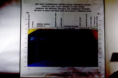
Dimly lit diagram of Florida hydrogeologic sections, showing depth relative to MSL (Mean Sea Level), from the Caloosahatchee River to the Atlantic Ocean.
Alt Text
A scientific diagram showing geological layers with labels and measurements. The image includes a color-coded cross-section of the earth's subsurface.
Keywords
Hydrogeology, Geology, Geologic cross sections
Extent
1 diagram
Subject: geographic
Martin County (Fla.); Lee County (Fla.); Glades County (Fla.); Fort Myers (Fla.); St. Lucie Inlet (Fla.); Caloosahatchee River (Fla.)
Physical Collection
Language
English
Media Type
Diagrams
Identifier
G16-00308
Recommended Citation
Parker, Garald Gordon, "Diagram, East-West Hydrogeologic Section across Peninsular Florida from St. Lucie Inlet, Stuart, to Fort Meyers Showing the Principal Geologic and Hydrologic Features" (1970). Dr. Garald Gordon Parker Collection - Images. Image 269.
https://digitalcommons.usf.edu/parker_photographs/269
Keywords
Hydrogeology, Geology, Geologic cross sections
Rights Statement

