

Dr. Garald Gordon Parker Collection - Images
Files
Download Full Text (6.4 MB)
Preview
Creation Date
11-9-1977
Abstract
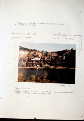
A view of the west-facing wall at the east end of the Old Story Mine in Citrus County. The photograph has been marked with water lines and the entrance to a cave. The caption below the image reads "Water level, 23.20 MSL, 11-09-77, is potentiometric surface of the Floridan Aquifer."
Alt Text
A photograph of a rocky cliff with water and vegetation in the foreground, annotated with various labels and measurements. The image includes handwritten notes and markings around its border.
Keywords
Floridan Aquifer, Aquifers, Potentiometry, Water levels
Extent
1 color photograph
Subject: geographic
Citrus County (Fla.)
Physical Collection
Language
English
Media Type
Color photographs
Identifier
G16-00272
Recommended Citation
Unknown, "Photograph, Story Mine Pit East End, Close-up View" (1977). Dr. Garald Gordon Parker Collection - Images. Image 233.
https://digitalcommons.usf.edu/parker_photographs/233
Keywords
Floridan Aquifer, Aquifers, Potentiometry, Water levels
Rights Statement

