

Dr. Garald Gordon Parker Collection - Images
Files
Download Full Text (9.8 MB)
Preview
Creation Date
1970
Time Period
circa 1970-1987
Abstract
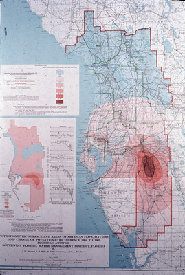
Map showing potentiometric surface and areas of artesian flow for May 1969 and change of potentiometric surface from 1964-1969 of the Floridan Aquifer for the Southwest Florida Water Management District, Florida.
Alt Text
Map showing potentiometric surface and areas of artesian flow for May 1969 and change of potentiometric surface from 1964-1969 of the Floridan Aquifer for the Southwest Florida Water Management District, Florida.
Keywords
Potentiometry, Floridan Aquifer, Aquifers, Artesian wells, Artesian basins, Southwest Florida Water Management District (Fla.)
Extent
1 map
Physical Collection
Language
English
Media Type
Maps
Identifier
G16-00143
Recommended Citation
Parker, Garald Gordon, "Map, Potentiometric Surface and Areas of Artesian Flow, May 1969, and Change of Potentiometric Surface 1964 to 1969, Floridan Aquifer, Southwest Florida Water Management District, Florida" (1970). Dr. Garald Gordon Parker Collection - Images. Image 104.
https://digitalcommons.usf.edu/parker_photographs/104
Keywords
Potentiometry, Floridan Aquifer, Aquifers, Artesian wells, Artesian basins, Southwest Florida Water Management District (Fla.)
Rights Statement

