

Dr. Garald Gordon Parker Collection - Images
Files
Download Full Text (7.4 MB)
Preview
Creation Date
2-17-1978
Abstract
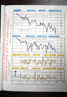
Four line graphs of water levels taken at different spots on the Floridan Aquifer and the Shallow Sand Aquifer. The top two graphs are for Brevard County. The third is for Indian River County, and the fourth for St. Lucie County.
Alt Text
A page from a book displaying multiple line graphs with various water level measurements over time, labeled with different locations and depths. The graphs are color-coded and include data points plotted on grids.
Keywords
Floridan Aquifer, Aquifers, Artesian wells, Artesian basins, Shallow Sand Aquifer (Fla.), Water levels
Extent
4 line graphs
Subject: geographic
Brevard County (Fla.); Indian River County (Fla.); St. Lucie County (Fla.)
Physical Collection
Language
English
Media Type
Line graphs
Identifier
G16-00139
Recommended Citation
Parker, Garald Gordon, "Line Graphs, Water Levels in Artesian and Nonartesian Aquifers of Florida, 1973-1974" (1978). Dr. Garald Gordon Parker Collection - Images. Image 100.
https://digitalcommons.usf.edu/parker_photographs/100
Keywords
Floridan Aquifer, Aquifers, Artesian wells, Artesian basins, Shallow Sand Aquifer (Fla.), Water levels
Rights Statement

