

Dr. Garald Gordon Parker Collection - Images
Files
Download Full Text (1.7 MB)
Preview
Creation Date
1977
Abstract
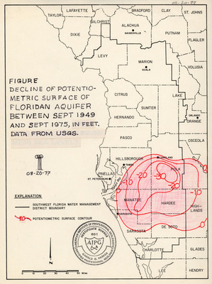
A map of the decline of potentio-metric surface of the Floridan Aquifer between September 1949 and September 1975 in feet, made with data from the U.S. Geological Survey. Legend includes the Southwest Florida Water Management District boundary, and potentiometric surface contour. Map is hand colored.
Alt Text
A map of Florida showing the decline of the potentiometric surface of the Floridan Aquifer between September 1949 and September 1975, with contour lines indicating changes in feet. The map includes county boundaries and a legend explaining the data.
Keywords
Floridan Aquifer, Aquifers, Southwest Florida Water Management District (Fla.), Geological Survey (U.S.), Potentiometry
Extent
1 map
Physical Collection
Box
10
Folder
6
Language
English
Media Type
Maps
Identifier
G16-00009
Recommended Citation
Parker, Garald Gordon, "Map, Decline of Potentio-Metric Surface of Floridan Aquifer Between September 1949 and September 1975" (1977). Dr. Garald Gordon Parker Collection - Images. Image 1.
https://digitalcommons.usf.edu/parker_photographs/1
Keywords
Floridan Aquifer, Aquifers, Southwest Florida Water Management District (Fla.), Geological Survey (U.S.), Potentiometry
Rights Statement

