
Binder 18: Photographs and Images
Files
Download
Download Full Text (3.7 MB)
Preview
Creation Date
1980
Abstract
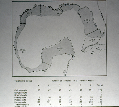
A photograph of an algae distribution map within the Gulf of Mexico.
Alt Text
A map with areas labeled with the letters A through F and a table at the bottom of the page listing the number of species in different taxonomic groups across these areas. The map depicts the coastal regions that surround the Gulf of Mexico.
Keywords
Maps, Geology
Extent
1 color photograph
Physical Collection
Box
6
Folder
Binder 18
Digital Date
2024
Media Type
Color photographs
Identifier
O19-02561
Recommended Citation
Ogden, John C., "Algae Distribution Map Within Gulf of Mexico" (1980). Binder 18: Photographs and Images. Image 127.
https://digitalcommons.usf.edu/ogden18_images/127
Keywords
Maps, Geology
Rights Statement

