
Irish Studies Publications
Files
Download
Download Full Text (77.7 MB)
Publisher
Charles Saunderson, Edward Stanford, George Herbert, and W. & A.K. Johnston
Publication Date
1840
Abstract
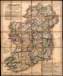
A map of Ireland with roads, railways, and towns portrayed as constructed since the Ordnance Survey of 1839. Also included is a list of banks in Dublin and Belfast and information for travelers to Ireland.
Keywords
Roads, Railroads
Extent
1 color map
Geographic Location
Ireland
Physical Collection
Irish Studies Collection
Call Number
Language
English
Digital Date
2023
Media Type
Maps
Identifier
I15-00068-1839
Recommended Citation
Saunderson, Charles and Dower, John, "Ireland, Shewing the Roads, Railways &C. Constructed Since the Ordnance Survey of 1839" (1840). Irish Studies Publications. 70.
https://digitalcommons.usf.edu/irish_publications/70
Rights Statement