
Gandy Photographs - Streets, Buildings, and Construction
Files
Download Full Text (6.7 MB)
Preview
Creation Date
6-2-1980
Abstract
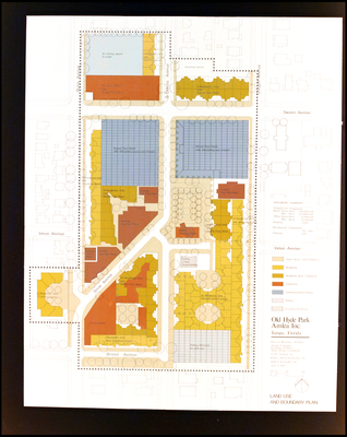
The land use and boundary plans for Old Hyde Park in Tampa, Florida created by Amlea Incorporated.
Alt Text
A detailed land use and boundary plan of Old Hyde Park Village in Tampa, Florida, showing various zones including residential, commercial, and open spaces. The map includes streets such as Swann Avenue, Bristol Avenue, and Inman Avenue with color-coded areas for different uses.
Keywords
Amlea (Florida) Inc., Building--Planning
Extent
1 map
Subject: geographic
Hillsborough County (Fla.); Tampa (Fla.); Old Hyde Park (Tampa, Fla.)
Physical Collection
Box
1
Digital Date
2024
Media Type
Maps
Feedback
Click to provide feedback about the metadata for this photograph.
Identifier
Gandy 01_1055_Undetermined
Recommended Citation
Unknown, "Land Use and Boundary Plan for Olde Hyde Park, Amlea Incorporated, A" (1980). Gandy Photographs - Streets, Buildings, and Construction. Image 81.
https://digitalcommons.usf.edu/gandy_street/81
Keywords
Amlea (Florida) Inc., Building--Planning
Image Location
Latitude
27.936944
Longitude
-82.475556
Rights Statement