

Gandy Photographs - Streets, Buildings, and Construction
Files
Download Full Text (6.3 MB)
Preview
Creation Date
6-2-1980
Abstract
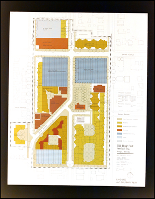
The land use and boundary plans for Old Hyde Park in Tampa, Florida created by Amlea Incorporated.
Alt Text
A detailed land use and boundary plan of Old Hyde Park in Tampa, Florida, showing various zones including residential, commercial, and open spaces. The map includes color-coded areas and a legend for easy reference.
Keywords
Amlea (Florida) Inc., Building--Planning
Extent
1 map
Subject: geographic
Hillsborough County (Fla.); Tampa (Fla.); Old Hyde Park (Tampa, Fla.)
Physical Collection
Box
1
Digital Date
2024
Media Type
Maps
Feedback
Click to provide feedback about the metadata for this photograph.
Identifier
Gandy 01_1064
Creative Commons

This work is licensed under a Creative Commons Attribution 3.0 License.
Recommended Citation
Gandy, George Skip IV, "Land Use and Boundary Plan for Olde Hyde Park, Amlea Incorporated, B" (1980). Gandy Photographs - Streets, Buildings, and Construction. Image 75.
https://digitalcommons.usf.edu/gandy_street/75
Keywords
Amlea (Florida) Inc., Building--Planning
