
Gandy Photographs - Streets, Buildings, and Construction
Files
Download Full Text (3.7 MB)
Preview
Creation Date
1970
Time Period
circa 1970s
Abstract
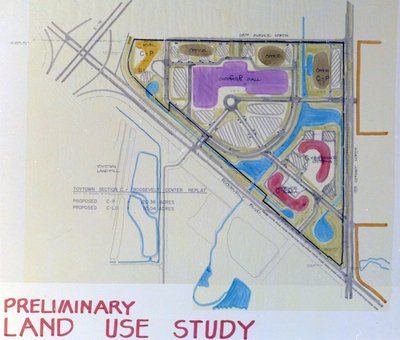
A color-coded map labeled “Toytown Section C – Roosevelt Center Replat” outlining proposed land uses including shopping mall, office space, motel, and civic center. Labeled areas indicate zoning designations C-P and C-LD. This image was taken in association with Charles Mayo.
Alt Text
A detailed map showing various land use zones and structures, including offices, parking lots, and recreational areas. The map is labeled "Preliminary Land Use Study" at the bottom.
Keywords
Land use, Zoning, Shopping malls, Office buildings, Urban planning
Extent
1 color photograph
Subject: geographic
Pinellas County (Fla.); St. Petersburg (Fla.)
Physical Collection
Box
30
Language
English
Digital Date
2024
Media Type
Color photographs
Feedback
Identifier
Gandy 30_1294_Undetermined
Recommended Citation
Gandy, George Skip IV, "Toytown Preliminary Land Use Study for Mayo, C" (1970). Gandy Photographs - Streets, Buildings, and Construction. Image 6629.
https://digitalcommons.usf.edu/gandy_street/6629
Keywords
Land use, Zoning, Shopping malls, Office buildings, Urban planning
Image Location
Latitude
27.876767
Longitude
-82.651216
Rights Statement