
Gandy Photographs - Streets, Buildings, and Construction
Files
Download Full Text (4.7 MB)
Preview
Creation Date
1970
Time Period
circa 1970s
Abstract
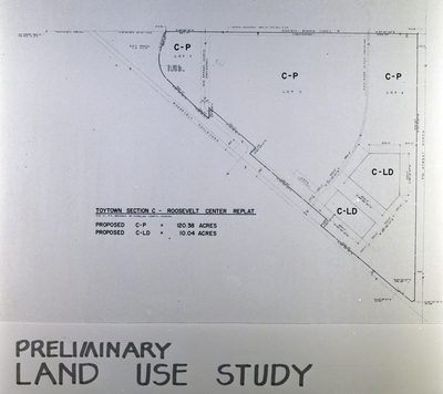
Land use map labeled “Toytown Section C – Roosevelt Center Replat” showing proposed commercial parcels. The map indicates 120.38 acres of proposed C-P zoning and 10.04 acres of proposed C-LD zoning. This image was taken in association with Charles Mayo.
Alt Text
A map labeled "Preliminary Land Use Study" showing different sections marked as C-P and C-LD with proposed acreage. The map includes measurements, lot numbers, and street names for a replat of Toytown Section C - Roosevelt Center.
Keywords
Land use, Zoning, Real estate development, Maps, Planning
Extent
1 black-and-white photograph
Subject: geographic
Pinellas County (Fla.); St. Petersburg (Fla.)
Physical Collection
Box
30
Language
English
Digital Date
2024
Media Type
Black-and-white photographs
Feedback
Identifier
Gandy 30_1292_Undetermined
Recommended Citation
Gandy, George Skip IV, "Toytown Preliminary Land Use Study for Mayo, A" (1970). Gandy Photographs - Streets, Buildings, and Construction. Image 6628.
https://digitalcommons.usf.edu/gandy_street/6628
Keywords
Land use, Zoning, Real estate development, Maps, Planning
Image Location
Latitude
27.876767
Longitude
-82.651216
Rights Statement