

Gandy Photographs - Natural Scenes and the Environment
Files
Download Full Text (45.1 MB)
Preview
Creation Date
1950
Time Period
circa 1950s-1960s
Abstract
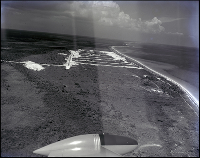
The view from an airplane of downtown Freeport on Grand Bahama Island, Bahamas showing roads, vegetations, structures, shoreline, and water. The wing of the plane is visible at the bottom of the frame.
Alt Text
Aerial view of shoreline with the ocean, large vegetation areas, and clouds in the background, seen through an airplane window. The wing of the plane is visible at the bottom right corner.
Keywords
Aerial views, Roads, Buildings, Vegetation, Shorelines, Water
Extent
1 black-and-white photograph
Subject: geographic
Freeport (Bahamas); Grand Bahama Island (Bahamas)
Physical Collection
Box
2
Digital Date
2024
Media Type
Black-and-white photographs
Feedback
Click to provide feedback about the metadata for this photograph.
Identifier
Gandy 02_0370
Creative Commons

This work is licensed under a Creative Commons Attribution 3.0 License.
Recommended Citation
Gandy, George Skip IV, "Aerial View of Downtown, Freeport, Bahamas, B" (1950). Gandy Photographs - Natural Scenes and the Environment. Image 65.
https://digitalcommons.usf.edu/gandy_environmental/65
Keywords
Aerial views, Roads, Buildings, Vegetation, Shorelines, Water
