

Files
Download
Download Full Text (8.9 MB)
Preview
Creation Date
1-23-1986
Abstract
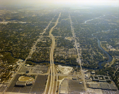
An aerial view of Tampa looking south past the intersection of Interstate Highway 275 and Bird Street, towards Davis Islands and Hillsborough Bay.
Alt Text
Aerial view of a city with a prominent highway running through the center, surrounded by buildings and greenery. The landscape includes various urban structures and natural elements.
Keywords
Interstate Highway System, Roads
Extent
1 color aerial photograph
Subject: geographic
Hillsborough County (Fla.); Tampa (Fla.)
Physical Collection
Box
28
Digital Date
2024
Media Type
Aerial photographs
Feedback
Identifier
Gandy 28_0067
Recommended Citation
Gandy, George Skip IV, "Interstate Highway 275 and Bird Street, D" (1986). Gandy Photographs - Aerials. Image 893.
https://digitalcommons.usf.edu/gandy_aerials/893
Keywords
Interstate Highway System, Roads
