

Files
Download Full Text (7.5 MB)
Preview
Creation Date
11-6-1984
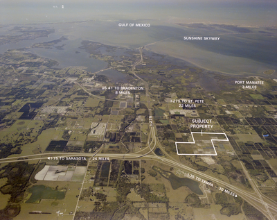
Abstract
An aerial view of I-75 with subject property markings that shows major roads and interchanges leading to Tampa, Sarasota, Bradenton, and Port Manatee, as well as other significant routes and features in the area.
Alt Text
Aerial view of a coastal area with labeled roads and landmarks, including the Gulf of Mexico and Sunshine Skyway. The image highlights various distances to nearby locations and a marked property.
Keywords
Interstate 75, Aerial photography, Rivers, Bays, Maps
Extent
1 color photograph
Subject: geographic
Manatee County (Fla.); Palmetto (Fla.)
Physical Collection
Box
27
Digital Date
2024
Media Type
Color photographs
Feedback
Identifier
Gandy 27_1649
Recommended Citation
Gandy, George Skip IV, "I-75 Subject Property Map" (1984). Gandy Photographs - Aerials. Image 702.
https://digitalcommons.usf.edu/gandy_aerials/702
Keywords
Interstate 75, Aerial photography, Rivers, Bays, Maps
