

Florida Ornithological Society - Images
Files
Download
Download Full Text (94.0 MB)
Preview
Creation Date
1-1-1981
Abstract
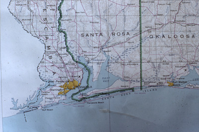
A paper map of the Florida Panhandle that is sectioned by county. To the west is Pensacola, Florida, where the U.S.'s first white-collared swift (Streptoprocne zonaris) specimen was found deceased and attached to the screen door of someone's beachside home.
Alt Text
A close-up of a paper map of the Florida Panhandle. The counties visible are: Escambia, Santa Rosa, and Okaloosa.
Keywords
Maps
Extent
1 map
Subject: geographic
Escambia County (Fla.); Santa Rosa County (Fla.); Okaloosa County (Fla.)
Physical Collection
Box
1
Folder
3
Digital Date
2023
Media Type
Color photographs
Identifier
fos_images_2356
Recommended Citation
Florida Ornithological Society, "Map of Florida Panhandle, C" (1981). Florida Ornithological Society - Images. Image 1357.
https://digitalcommons.usf.edu/fos_images/1357
Keywords
Maps
Rights Statement

