

Florida Maps Collection
Files
Download Full Text (1.0 MB)
Preview
Creation Date
1740
Abstract
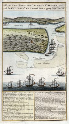
A perspective map of St. Augustine showing an account of the siege of St. Augustine along with a letter from on board the ship Hector. The map is quite detailed showing ships with their names in a key, a key for physical features and troop positions, houses, Castillo de San Marcos, water depths, and military camps. The text from the letter beneath the map that explains the siege in detail.
Alt Text
A map showing the town and castle of St. Augustine, as well the English camp as it was on June 20th 1740. The map has a key below it where letters and numbers correspond to map features.
Keywords
St. Augustine Expedition (1740)
Scale
Not drawn to scale
Extent
1 map
Subject: geographic
St. Johns County (Fla.); St. Augustine (Fla.)
Language
English
Media Type
Map
Identifier
U15-9038
Recommended Citation
Silver, Thomas, "Map, View of the Town and Castle of St. Augustine, and the English Camp Before It, June 20, 1740" (1740). Florida Maps Collection. Image 90.
https://digitalcommons.usf.edu/fl_maps_collection/90
Keywords
St. Augustine Expedition (1740)
Rights Statement

