

Florida Maps Collection
Files
Download Full Text (1.4 MB)
Preview
Publisher
T. Cadell
Creation Date
1783
Abstract
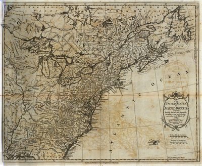
The map shows the United States extending to the Mississippi River, with the former colonial claims now independent states. The states of Georgia, South Carolina, North Carolina, and Virginia stretch from the Atlantic to the Mississippi. The map shows early settlements, forts, Indian villages and fishing banks. One of the first maps published following the American Revolution.
Alt Text
Map showing the Eastern United States with rivers, mountains, and states labeled.
Keywords
Treaty of Paris (1783), American Revolution (1775-1783)
Scale
6750000, Scale 1:6,500,000
Extent
1 map
Physical Collection
Rare Map Collection
Call Number
Language
English
Media Type
Map
Identifier
U15-0074
Recommended Citation
Kitchin, Thomas, "Map, United States in North America, 1783" (1783). Florida Maps Collection. Image 82.
https://digitalcommons.usf.edu/fl_maps_collection/82
Keywords
Treaty of Paris (1783), American Revolution (1775-1783)
Rights Statement

