

Florida Maps Collection
Alternative Title
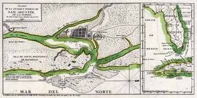
Map, Map of the City and Port of St. Augustine, Florida, 1783
Files
Download Full Text (12.9 MB)
Preview
Creation Date
1783
Abstract
A hand-colored map of the St. Augustine region and its port. The map also shows Fuerte Negro (Fort Mose) which was the first legally sanctioned free Black community in the present-day U.S. Includes an inset with Florida and Cuba.
Alt Text
Map of the town of St. Augustine including "Indian Villages" and "Fuerte Negro". An inset map shows the Florida peninsula and Cuba.
Keywords
Harbors
Scale
49000, Scale [ca. 1:49,000].
Extent
1 map
Subject: geographic
St. Johns County (Fla.); St. Augustine (Fla.)
Physical Collection
Rare Map Collection
Language
Spanish
Media Type
Map
Identifier
U15-9010
Recommended Citation
López de Vargas Machuca, Tomás, "Map, Plano de la Ciudad y Puerto de San Agustin de la Florida, 1783" (1783). Florida Maps Collection. Image 169.
https://digitalcommons.usf.edu/fl_maps_collection/169
Keywords
Harbors
Rights Statement

