

Florida Maps Collection
Files
Download
Download Full Text (1.1 MB)
Preview
Publisher
J.F.W. Des Barres
Creation Date
1780
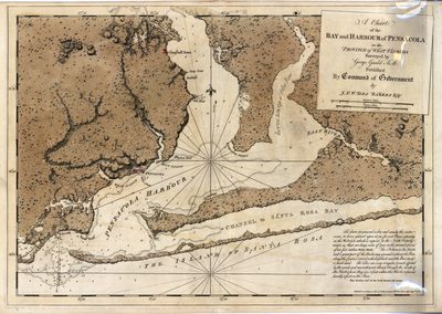
Abstract
A map of Pensacola Harbor and the islands of Santa Rosa in Florida.
Alt Text
A map of Pensacola Harbor and the islands of Santa Rosa in Florida.
Keywords
Harbors, Nautical charts
Scale
64000, Scale [ca. 1:64,000].
Extent
1 map
Subject: geographic
Escambia County (Fla.); Pensacola (Fla.); Santa Rosa Island (Fla.); Pensacola Bay (Fla.),
Language
English
Media Type
Map
Identifier
U15-0053
Recommended Citation
Gauld, George, "Map, Chart of the Bay and Harbour of Pensacola in the Province of West Florida, August 1780, A" (1780). Florida Maps Collection. Image 56.
https://digitalcommons.usf.edu/fl_maps_collection/56
Keywords
Harbors, Nautical charts
Rights Statement

