

Florida Maps Collection
Files
Download Full Text (1.4 MB)
Preview
Publisher
Samuel Augustus Mitchell
Creation Date
1846
Abstract
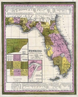
This map of Florida shows towns, forts, roads, canals, major rivers and lakes in Florida. There are references to forts, battlefields, and routes used by the Army during the Seminole War. There are also three inset maps detailing Pensacola, Tallahassee, and St. Augustine. Water routes from St. Augustine and Pensacola to various ports are described along the upper and lower margins.
Alt Text
Map of Florida showing counties in varying colors. Inset maps exist for St. Augustine, Tallahassee, and Pensacola. The edges of the map include information on water routes.
Keywords
Forts and fortifications 2nd Seminole War (1835-1842)
Scale
3218688, Scale [ca. 1:3,218,688].
Extent
1 map
Subject: geographic
Escambia County (Fla.); Leon County (Fla.); St. Johns County (Fla.); Pensacola (Fla.); Tallahassee (Fla.); St. Augustine (Fla.)
Physical Collection
Rare Map Collection
Call Number
Language
English
Media Type
Map
Identifier
U15-0061
Recommended Citation
Mitchell, Samuel Augustus, "Map, Florida, 1846" (1846). Florida Maps Collection. Image 79.
https://digitalcommons.usf.edu/fl_maps_collection/79
Keywords
Forts and fortifications 2nd Seminole War (1835-1842)
Rights Statement

