

Florida Maps Collection
Files
Download Full Text (1.4 MB)
Preview
Publisher
Thomas Bowles, John Bowles, and I. King
Creation Date
1731
Abstract
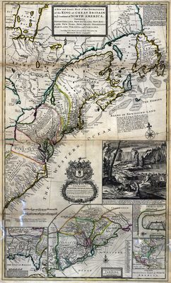
A map "containing Newfoundland, New Scotland, New England, New York, New Jersey, Pensilvania, Maryland, Virginia, and Carolina according to the newest and most exact observations." Insets include beaver industry of Canada; the cataract of Niagara; Charleston harbor; "a map of the principal part of North America;" "A map of the improved part of Carolina with the settlements;" and South Carolina and the east part of Florida.
Alt Text
A map showing the Northeast United States with the Atlantic Ocean labeled as the Western Ocean. Four inset maps exist for the Southeast United Sates, the Carolinas, North America, and Charles-town.
Keywords
Colonial cities, Colonies
Scale
3168000, Scale [ca. 1:3,168,000]
Extent
1 map
Subject: geographic
Atlantic Coast (North America), North America, Great Britain, East (U.S.)
Physical Collection
Rare Map Collection
Language
English
Media Type
Map
Identifier
U15-0058
Recommended Citation
Moll, Herman, "Map, New and Exact Map of the Dominions of the King of Great Britain on Ye Continent of North America, 1731" (1731). Florida Maps Collection. Image 77.
https://digitalcommons.usf.edu/fl_maps_collection/77
Keywords
Colonial cities, Colonies
Rights Statement

