

Florida Maps Collection
Files
Download
Download Full Text (1.3 MB)
Preview
Publisher
Thomas Bowles and John Bowles
Creation Date
1736
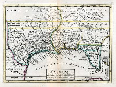
Abstract
A map of Florida and the rest of the Gulf Coast to what is now Texas. Includes the names of Indigenous nations in addition to geographical features.
Alt Text
A map of Florida and the rest of the Gulf Coast to what is now Texas. Includes the names of Indigenous nations in addition to geographical features.
Scale
Scale not given
Extent
1 map
Subject: geographic
South Carolina; Alabama; Mississippi; Louisiana; Texas
Language
English
Media Type
Map
Identifier
U15-9057
Recommended Citation
Moll, Herman, "Map, Florida: The North Part of the Gulf of Mexico with Adjacent Territories Belonging to Great Britain and to France, 1736" (1736). Florida Maps Collection. Image 106.
https://digitalcommons.usf.edu/fl_maps_collection/106
Rights Statement

