

Florida Maps Collection
Files
Download
Download Full Text (1.4 MB)
Preview
Publisher
O.W. Gray & Son
Creation Date
1875
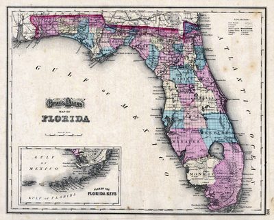
Abstract
A detailed map of Florida showing counties, cities, roads, railroads, and inland waters, with an inset of the Plan of the Florida Keys.
Alt Text
Map of Florida with counties shown in varying colors.
Keywords
Railroads
Scale
2600000, Scale [ca. 1:2,600,000]
Extent
1 map
Physical Collection
Rare Map Collection
Language
English
Media Type
Map
Identifier
U15-0043
Recommended Citation
Gray, Ormando Willis, "Map, Gray's Atlas Map of Florida, 1875" (1875). Florida Maps Collection. Image 74.
https://digitalcommons.usf.edu/fl_maps_collection/74
Keywords
Railroads
Rights Statement

