

Florida Maps Collection
Alternative Title
Atlas of the United States
Files
Download
Download Full Text (1.6 MB)
Preview
Publisher
Stedman, Brown & Lyon
Creation Date
1873
Abstract
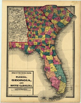
A map of Florida, Georgia, and South Carolia that shows county lines of the period, and Florida railroad routes between Fernandina and Cedar Keys; Jacksonville and Tallahassee; St. Marks and Tallahassee; Live Oak and Lowton, Georgia; Tallahassee and Chattahoochee; and Pensacola and Pollard, Georgia
Alt Text
Map of Florida, Georgia, South Carolina, and part of Alabama, showing counties in varying colors.
Keywords
Railroads
Scale
3000000, Scale 1:3,000,000
Extent
1 map
Subject: geographic
Georgia; South Carolina
Physical Collection
Rare Map Collection
Call Number
Language
English
Media Type
Map
Identifier
U15-0015
Recommended Citation
Martenet, Simon J., "Map, Florida, Georgia, and South Carolina, 1873" (1873). Florida Maps Collection. Image 4.
https://digitalcommons.usf.edu/fl_maps_collection/4
Keywords
Railroads
Rights Statement

