

Florida Maps Collection
Alternative Title
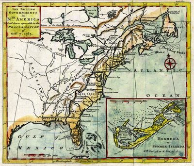
British governments in North America
Files
Download Full Text (1.1 MB)
Preview
Creation Date
1763
Abstract
A map of the British governments in North America as "laid down agreeable to the Proclamation of October 7, 1763." Includes locations of Indigenous peoples and an inset for Bermuda.
Alt Text
Map of the Southeast United States with some rivers and mountains marked. The Florida Peninsula is shown as a series of islands.
Keywords
Indigenous peoples, Great Britain--Colonies
Scale
15206000, Scale [ca. 1:15,206,000]..
Extent
1 map
Subject: geographic
Georgia; South Carolina; North Carolina; Virginia; Maryland; Delaware; Pennsylvania; New York; Connecticut; Rhode Island; New Jersey; Massachusetts; New Hampshire; Canada; Nova Scotia (Canada); Quebec (Canada); Bermuda
Physical Collection
Rare Map Collection
Call Number
Language
English
Media Type
Map
Identifier
U15-0031
Recommended Citation
Gibson, John, "Map, British Governments in Nth America. 1763" (1763). Florida Maps Collection. Image 72.
https://digitalcommons.usf.edu/fl_maps_collection/72
Keywords
Indigenous peoples, Great Britain--Colonies
Rights Statement

