

Florida Maps Collection
Alternative Title
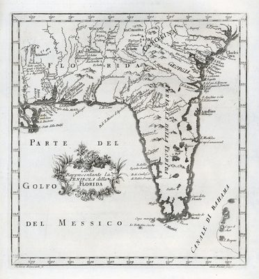
Map, Map Showing the Peninsula of Florida
Files
Download
Download Full Text (1.2 MB)
Preview
Creation Date
1763
Abstract
A map showing the southeastern United States, west to Pearl River, Louisiana and Mississippi, and north to latitude 34 degrees.
Alt Text
Map of Florida, Georgia, and North Carolina. The map depicts waterbodies and mountains.
Scale
6000000, Scale [ca. 1:6,000,000].
Extent
1 map
Subject: geographic
Georgia
Physical Collection
Touchton Map Collection
Holding Location
Tampa Bay History Center
Language
Italian
Media Type
Map
Identifier
U15-9033
Recommended Citation
Scacciati, Andrea and Pazzi, Giuseppe, "Map, Carta Rappresentante la Penisola della Florida, 1763" (1763). Florida Maps Collection. Image 59.
https://digitalcommons.usf.edu/fl_maps_collection/59
Rights Statement

