

Florida Maps Collection
Files
Download
Download Full Text (1.1 MB)
Preview
Publisher
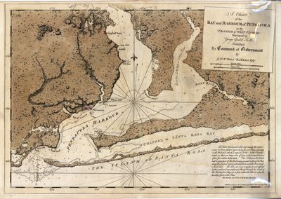
Published by command of government by J.F.W. Des Barres
Creation Date
1780
Time Period
1780
Keywords
Pensacola, Pensacola Bay (Fla.), Florida, Florida, Harbors, Nautical charts
Subject: geographic
Pensacola, Pensacola Bay (Fla.), Florida, Florida
Holding Location
University of South Florida Library
Language
English
Format
Map
Identifier
U15-0053
Recommended Citation
Gauld, George, "A chart of the bay and harbour of Pensacola in the Province of West Florida" (1780). Florida Maps Collection. Image 56.
https://digitalcommons.usf.edu/fl_maps_collection/56
Keywords
Pensacola, Pensacola Bay (Fla.), Florida, Florida, Harbors, Nautical charts
Rights Statement

