

Florida Maps Collection
Files
Download
Download Full Text (1.2 MB)
Preview
Publisher
Matthews-Northrup Company
Creation Date
1890
Time Period
circa 1890-1900
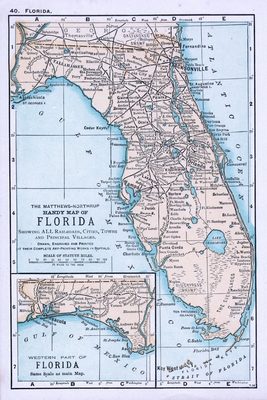
Abstract
A map of Florida with an inset for the westernmost part of the Panhandle, showing "all railroads, cities, towns and principal villages."
Alt Text
Map of Florida with counties shown in varying colors. An inset map shows the panhandle of Florida.
Keywords
Railroads
Scale
4752000, Scale [1:4,752,000].
Extent
1 map
Language
English
Media Type
Map
Identifier
U15-9052
Recommended Citation
Matthews-Northrup Company, "Map, Matthews-Northrup Handy Map of Florida, circa 1890-1900" (1890). Florida Maps Collection. Image 28.
https://digitalcommons.usf.edu/fl_maps_collection/28
Keywords
Railroads
Rights Statement

