

Florida Maps Collection
Files
Download
Download Full Text (1.2 MB)
Preview
Publisher
Rand, McNally and Company
Creation Date
1883
Abstract
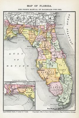
A railroad map of Florida with an inset map showing the western Panhandle. Shows railroads, counties, cities and towns, and inland waters.
Alt Text
Map of Florida with counties shown in varying colors. An inset map shows the panhandle of Florida.
Keywords
Railroads
Scale
4752000, Scale [ca. 1:4,752,000].
Extent
1 map
Language
English
Media Type
Map
Identifier
U15-9048
Recommended Citation
Rand, McNally and Company, "Map, Florida for Poor's Manual of Railroads for 1883, 1883" (1883). Florida Maps Collection. Image 24.
https://digitalcommons.usf.edu/fl_maps_collection/24
Keywords
Railroads
Rights Statement

