

Florida Maps Collection
Preview
Publisher
Pasco County (Fla.). Office of the County Surveyor
Creation Date
1-6-1928
Abstract
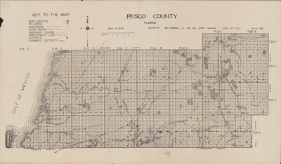
A map of Pasco County, Florida, showing Range 15 East to Range 22 East (marked as "R" on the map) and Township 23 South to Township 26 South (marked as "S" on the map). A key includes post offices, villages, railroads, hard roads, ordinary roads, high-power lines, schools, and commissioner's districts.
Alt Text
Map of Pasco County showing Section, Township, and Ranges. Information on railroads, roads, power lines, and schools is shown on the map.
Keywords
Development, Surveying, Roads, Infrastructure, Railroads, Powerlines
Extent
1 map
Subject: geographic
Pasco County (Fla.)
Physical Collection
General Map Collection
Call Number
Language
English
Digital Date
2025
Media Type
Maps
Identifier
U15-9062
Recommended Citation
Sparkman, William A., "Map, Pasco County, Florida, January 6, 1928" (1928). Florida Maps Collection. Image 177.
https://digitalcommons.usf.edu/fl_maps_collection/177
Keywords
Development, Surveying, Roads, Infrastructure, Railroads, Powerlines
Rights Statement

