

Florida Maps Collection
Files
Download
Download Full Text (7.6 MB)
Preview
Publisher
J. Bew
Creation Date
1783
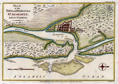
Abstract
A map of St. Augustine and its harbor. The map also shows Fuerte Negro (Fort Mose) which was the first legally sanctioned free Black community in the present-day U.S. The map shows forts, Indigenous towns, and General Oglethorpe's Landing Place.
Alt Text
A map of St. Augustine and its harbor. Shown is the town of St. Augustine as well as the "Indian town" and "Negroe fort".
Keywords
Harbors
Scale
60000, Scale [ca. 1:60,000].
Extent
1 map
Subject: geographic
St. Johns County (Fla.); St. Augustine (Fla.)
Language
English
Media Type
Map
Identifier
U15-9009
Recommended Citation
Lodge, John, "Map, Plan of the Town and Harbour of St. Augustin in East Florida, 1783" (1783). Florida Maps Collection. Image 159.
https://digitalcommons.usf.edu/fl_maps_collection/159
Keywords
Harbors
Rights Statement

