

Florida Maps Collection
Alternative Title
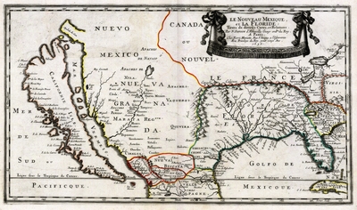
Map, New Mexico and Florida, 1656
Files
Download
Download Full Text (29.1 MB)
Preview
Publisher
Chez Pierre Mariette
Creation Date
1656
Abstract
A map of the southwest of the United States from 1656. Included are areas marked for "New Mexico," "New Canada," and "Florida." Includes the names of Indigenous peoples.
Alt Text
A map of the United States with California depicted as an island. Included are names of Indigenous peoples.
Scale
Scale not given
Extent
1 map
Subject: geographic
Mexico; Old California
Physical Collection
Touchton Map Collection
Holding Location
Tampa Bay History Center
Language
French
Media Type
Map
Identifier
U15-9002
Recommended Citation
Sanson, Nicolas, "Map, Le Nouveau Mexique et la Floride, 1656" (1656). Florida Maps Collection. Image 165.
https://digitalcommons.usf.edu/fl_maps_collection/165
Rights Statement

