

Florida Maps Collection
Files
Download
Download Full Text (1.1 MB)
Preview
Publisher
Asher & Adams
Creation Date
1871
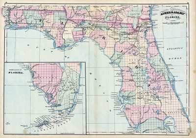
Abstract
This 1871 map of Florida shows county lines and county seats current to the period, major towns and cities, and railroad routes and stations. Includes an inset of the southern end of Florida.
Alt Text
Map of Florida with counties shown in varying colors. An inset map shows the southern tip of Florida.
Scale
1267200, Scale [1:1,267,200]. 20 mi. to an in.
Extent
1 map
Physical Collection
Rare Map Collection
Call Number
Language
English
Media Type
Map
Identifier
U15-0079-A
Recommended Citation
Asher & Adams, "Map, Asher and Adams' Florida, 1871" (1871). Florida Maps Collection. Image 15.
https://digitalcommons.usf.edu/fl_maps_collection/15
Rights Statement

