

Florida Maps Collection
Files
Download Full Text (19.3 MB)
Preview
Publisher
United States. Department of the Interior
Creation Date
1881
Abstract
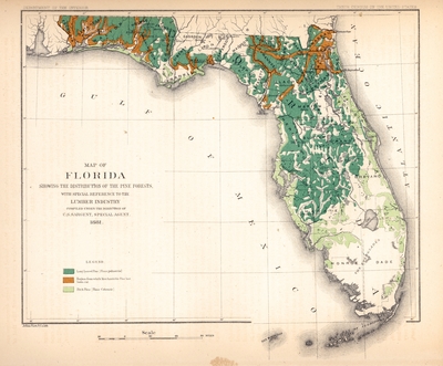
A map of Florida showing the distribution of pine forests with special reference to the lumbar industry. It has a key showing three different sections and two species of pine: Long Leaved Pine, Region from which Merchantable Pine has been cut, and Pitch Pine. It also shows cities, towns and counties.
Alt Text
A map of Florida showing the distribution of pine forests in Florida.
Keywords
Pine, Lumber trade
Scale
550240, Scale [ca. 1:550,240].
Extent
1 map
Physical Collection
Touchton Map Collection
Holding Location
Tampa Bay History Center
Language
English
Media Type
Map
Identifier
U15-9061
Recommended Citation
Sargent, Charles Sprague and Scott, R. H., "Map, Map of Florida Showing the Distribution of the Pine Forests, 1881" (1881). Florida Maps Collection. Image 140.
https://digitalcommons.usf.edu/fl_maps_collection/140
Keywords
Pine, Lumber trade
Rights Statement

