

Florida Maps Collection
Files
Download
Download Full Text (446.7 MB)
Preview
Publisher
William Bradley & Brothers
Creation Date
1889
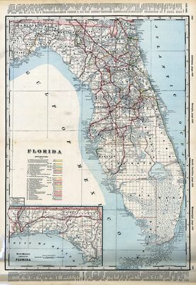
Abstract
A detailed map of Florida showing counties, railroads, cities, inland waters. Insets: Northwestern portion of Florida. Originally published in Bradley's Atlas of the World for Commercial and Library Reference
Alt Text
Map of Florida with counties, roads, and railway line shown. An index on the edges of the map lists cities.
Keywords
Railroads
Scale
1267200, Scale [1:1,267,200]. 20 mi. to 1 in.
Extent
1 map
Physical Collection
Rare Map Collection
Language
English
Media Type
Map
Identifier
U15-0041
Recommended Citation
William M. Bradley and Brothers, "Map, Florida, 1889" (1889). Florida Maps Collection. Image 10.
https://digitalcommons.usf.edu/fl_maps_collection/10
Keywords
Railroads
Rights Statement

