

Florida Maps Collection
Files
Download
Download Full Text (1.6 MB)
Preview
Publisher
Longmans, Green & Company
Creation Date
1890
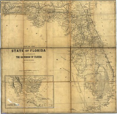
Abstract
A map of Florida showing counties, county seats, cities, railroads, rivers, and the Everglades. The longitude on this map goes by the Washington Meridian. Includes an inset map of the United States.
Alt Text
Map of Florida showing railroad lines and cities. An inset map exists showing a map of the United States.
Keywords
Railroads
Scale
1457280, Scale [ca. 1:1,457,280]
Extent
1 map
Physical Collection
Rare Map Collection
Call Number
Language
English
Media Type
Map
Identifier
U15-0019
Recommended Citation
Fisk & Company, "Map, State of Florida to Accompany the Handbook of Florida, 1890" (1890). Florida Maps Collection. Image 1.
https://digitalcommons.usf.edu/fl_maps_collection/1
Keywords
Railroads
Rights Statement

