
Cape Canaveral Space Force Station – 3D Historic Launch Complexes
Browse the 3D Collections for the Cape Canaveral Space History Collection below.
-

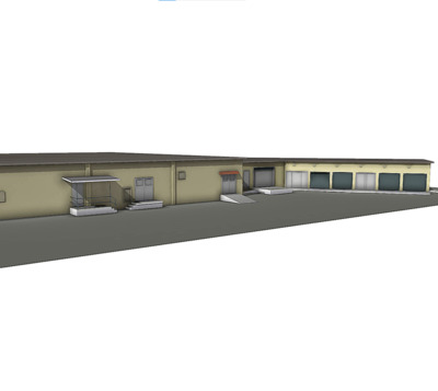
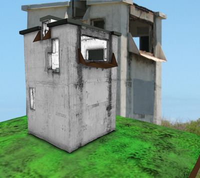
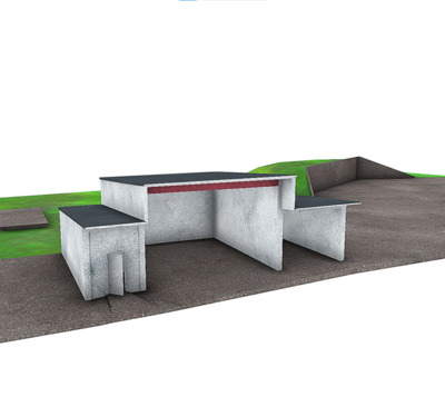
Apollo LC 34 Launch Pad Environmental Building
Center for Digital Heritage and Geospatial Information
This is a portion of the building relating to the LC34 pad structure, and consists of smoothed cement finished area with one standing wall and three smaller, curb-like walls. Laser scanned with phase shift scanner, and also documented with imagery and GPS survey. See also: https://vimeo.com/173126179.
-

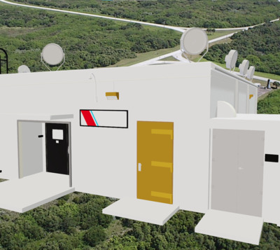
Area 55 Administrative Building
Center for Digital Heritage and Geospatial Information
The Area 55 Administration Building is a now former facility at Cape Canaveral Space Force Station. A 3D laser scanning survey of the entire complex was performed prior to changes of architectural impact at this site.
-

Area 55 Delta 2nd Stage Checkout
Center for Digital Heritage and Geospatial Information
This ideal model derived from 3D laser scan data is of Facility 56636 in Area 55, the Delta 2nd Stage Checkout Bldg. (Florida Master Site File #BR3030). This structure is no longer extant.
-

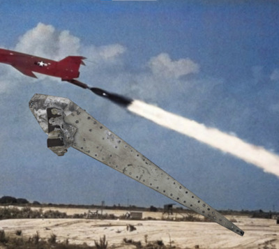
Ballistic Missile Part
Center for Digital Heritage and Geospatial Information
Historic ballistic missile part recovered from archaeological context at Cape Canaveral Space Force Station, Florida. Stamped numbers of the piece, although heavily worn, are evident from scanning and imaging- revealed as 5478120 E. Additionally, there are QA/QC stamps on the piece indicative of inspections that include: S 215 and 272 and 187 numbers. The piece is possibly from a Matador intermediate range cruise missile (IRCM) that was used at Cape Canaveral, Florida. Note the Lighthouse at Cape Canaveral shown in relation to the launch in this image.
-

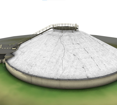
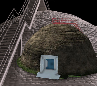
Beehive Blockhouse at Launch Complex 31 and 32
Center for Digital Heritage and Geospatial Information
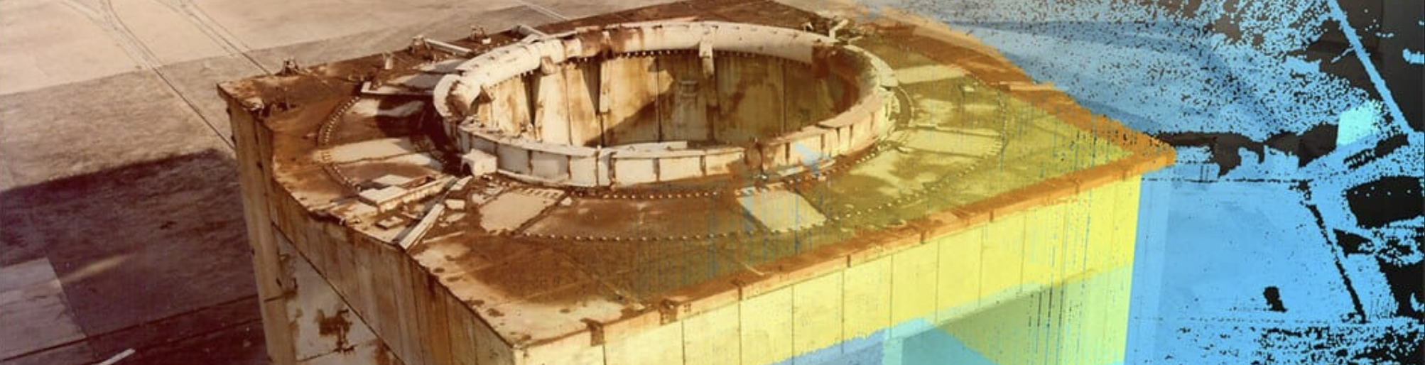
There are two of these unique beehive structures on a dual historic launch complex at Cape Canaveral Space Force Station in Brevard County, Florida. These blockhouses served as a central command for the launching of ICBMs- Minuteman missiles-during the 1960s Cold War Era. The underground missile silos at the complexes contains the buried debris from the Space Shuttle Challenger explosion. Today LC 31 and LC32 are abandoned, and facing impacts from climate and weathering, invasive plant exotics, and the ravages of time. The interiors of the structures pose an asbestos hazard. Exteriors were documented using terrestrial laser scanning while the insides were CAD modeled based on existing as-built paper designs converted to 3D.
-

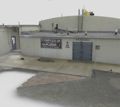
Blockhouse at Historic Launch Complex 26
Center for Digital Heritage and Geospatial Information
The Center for Digital Heritage and Geospatial Information are using terrestrial LiDAR to document historic launch complexes at Cape Canaveral Space Force Station, including the significant site of the LC 26 blockhouse. Constructed for the Redstone and Jupiter missile programs in 1956-1957, the blockhouse was only about 400 feet from the launch pads and had to be explosion proof. The walls of the blockhouse are two-feet thick, and the dome-shaped roof is from five-feet to nearly eight-feet thick. Further explosion proofing measures at the site include windows that are about one foot thick and blast doors that are made with heavy armor-like plating.
-

Blockhouse at Launch Complex 14
Center for Digital Heritage and Geospatial Information
Launch Complex 14 was declared a National Historic Landmark in 1984. In 1988, the blockhouse was restored and converted to meeting space to commemorate the 35th Anniversary of the final Mercury flight. Historically, the Atlas research and development testing program began at this site in 1957, and the US Air Force would conduct Atlas test launches at Complexes 11, 12, 13, and 14 through 1962. The site is more famously associated with the four crewed Atlas Mercury launches including Friendship 7, where John Glenn became the first American to successfully accomplish a human orbital flight mission. Glenn circled the earth three times aboard Mercury/Atlas (MA-6) on February 20, 1962. Other notable crewed Project Mercury missions from LC14 were the Aurora 7, with Scott Carpenter in 1962, the Sigma 7 with Walter M. Schirra, Jr. in 1962, and the Faith 7 with Gordon Cooper’s 22-orbit flight, in 1963.
-

Blockhouse at Launch Complex 19
Center for Digital Heritage and Geospatial Information
This launch complex was used by NASA for all of the Gemini manned spaceflights, as well as the unmanned Titan I and Titan II missiles. It was built in 1959 by the US Army Corp of Engineers. The structure is made of reinforced concrete, with the site including a ready room, launch ramp and test stand along with the impressive the launch control center (Blockhouse). This structure was documented using a phase shift laser scanner as well as photogrammetry, imaging, and GPS survey. Listed as 8BR2261 with the Florida Master Site File. See our docu-short on our 3D project: https://vimeo.com/manage/videos/365904796
-

Blockhouse at Launch Complex 1 and 2
Center for Digital Heritage and Geospatial Information
Blockhouses 1 and 2 at Cape Canaveral Space Force Station, Florida. Constructed in the early 1950s to oversee Snark winged missile program activities, this blockhouse had four-inch thick, tempered laminated glass and was connected to the pads via underground tunnels. Visual observations of the pads were made through a pair of mirrors that reflected images of the launch pads through the tempered glass windows and downward to observers within the blockhouse. An observation deck was located on the roof, and a two-story tower was added at the rear to assist in the tethered aerostat radar program . The building was abandoned during the mid-1990s, and we are using 3D laser scanning and GIS strategies to map and conduct archaeological heritage surveys at the site.
-

Blockhouse at Launch Complex 3 and 4
Center for Digital Heritage and Geospatial Information
The complex was constructed between 1950 and 1953, and was used throughout the 1950s including for the Bumper, Matador, Bomarc, Lark, X-17, Polaris FTV, and Redstone missile programs. Launch Complex 3 and 4 was considered to be technologically advanced for its time, and the facilities would later be modified for medical support area for the Mercury Project. The historic launch complexes at Cape Canaveral are being recorded using 3D and imaging technologies and a GIS survey approach as part of a historic preservation and documentation program partnership with University of South Florida researchers and the US Space Force.
-

Blockhouse at Launch Complex 9-10
Center for Digital Heritage and Geospatial Information
Constructed between 1953 and 1957, Launch Complex 9-10 at CCSFS was designed to support the Air Force’s Navaho winged intercontinental missile program. Although the Navaho program was cancelled soon after completion of the complex, test flights continued until November 1958. The complex was deactivated in 1959. Several of the facilities at the launch complex were reused for the Minuteman missile program- part of Launch Complex 31-32.
-

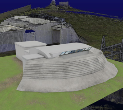
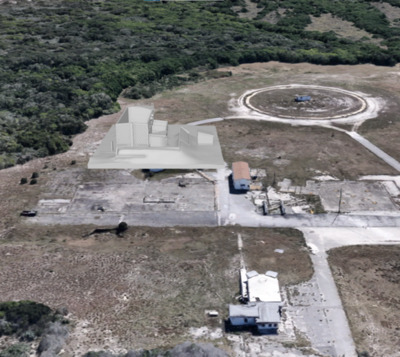
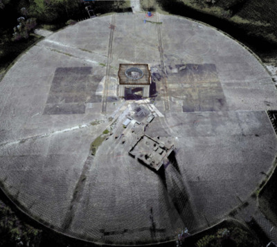
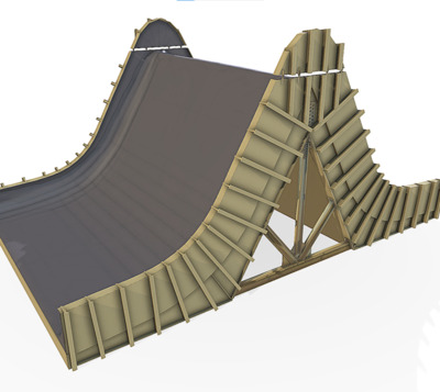
Bomarc Building, Cape Canaveral
Center for Digital Heritage and Geospatial Information
The Air Force first launched the Bomarc missile from Complex 4 on September 10, 1952. The defensive winged missile was designed to intercept and destroy enemy aircraft. The building was uniquely constructed to launch the Bomarc missile with a roof that could split right and left down the middle, allowing the missile to be raised prior to a quick launch. Today, remnants of rockets and control panels are located inside the otherwise abandoned historic building. Using laser scanning and historic CAD drawings we have recreated the floor plan.
-

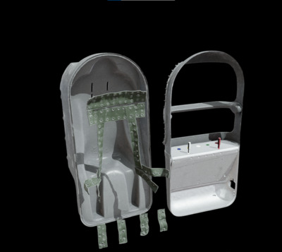
Chimpanzee Space Couch 3D Animation
Center for Digital Heritage and Geospatial Information
A Chimpanzee named Ham was secured in a flight couch just like this one and placed in a Mercury space capsule attached to a Redstone rocket. Ham, an acronym for Holloman Aerospace Medicine, was the first chimpanzee in space, completing a sub-orbital flight on January 31, 1961. Primates were used as a surrogate for humans, testing impacts from noise, acceleration, vibration, re-entry, and zero gravity before crewed flights were undertaken. This couch, and information on primates in space, is part of a display at the Air Force Space and Missile Museum at Launch Complex 26, Cape Canaveral, Florida. For more on Ham- his life and death- see: https://airandspace.si.edu/stories/editorial/mercury-primate-capsule-and-ham-astrochimp see also: https://www.theguardian.com/science/animal-magic/2013/dec/16/ham-chimpanzee-hero-or-victim
-

Chimpanzee Space Flight Couch
Center for Digital Heritage and Geospatial Information
A Chimpanzee named “Ham” was secured in a flight couch just like this one, and placed in a Mercury space capsule attached to a Redstone rocket. “Ham”, an acronym for Holloman Aerospace Medicine, was the first chimpanzee in space, completing a sub-orbital flight on January 31, 1961. Primates were used as a surrogate for humans, testing impacts from noise, acceleration, vibration, re-entry, and zero gravity before crewed flights were undertaken. This couch, and information on primates in space, is part of a display at the Air Force Space and Missile Museum, Cape Canaveral, Florida. Ham died in 1983 and his skeleton is part of the National Museum of Health and Medicine’s collection in Washington, D.C. For more about Ham, his life, and death, see: https://airandspace.si.edu/stories/editorial/mercury-primate-capsule-and-ham-astrochimp see also: https://www.theguardian.com/science/animal-magic/2013/dec/16/ham-chimpanzee-hero-or-victim
-

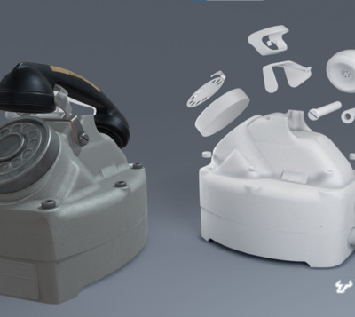
Explosion Proof Telephone
Center for Digital Heritage and Geospatial Information
This is one of two explosion-proof telephones saved from Launch Complex 37 at Cape Canaveral Space Force Station, Brevard County, Florida. The digital collection collaboration with the 45th Space Wing and the Cape Canaveral Air Force Space & Missile Museum and the University of South Florida Libraries (Center for Digital Heritage and Geospatial Information) is documenting a number of artifacts and sites relating to early launch complexes and the race to space. This piece was captured using a structured light 3D scanner. While the exact provenance is not known, these types of phones played a role in the early blockhouse and launch complex facilities and originated from LC37 that was operational from 1959-1972, supporting the Saturn programs and the first uncrewed launch of the Apollo Lunar Module in space.
-

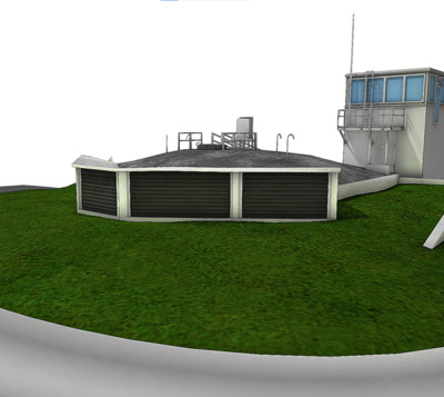
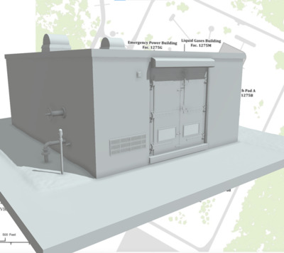
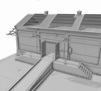
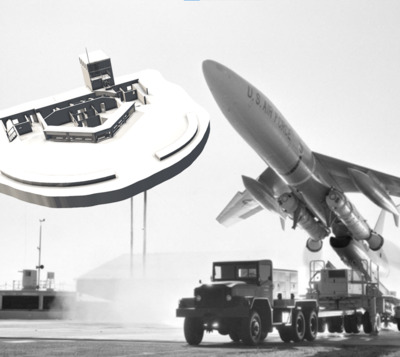
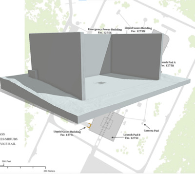
Facility 1275G Emergency Power at LC-26
Center for Digital Heritage and Geospatial Information
This structure is part of Launch Complex 26 at Cape Canaveral Space Force Station, Brevard County, Florida. This historic complex has served two primary functions – as a launch facility and as a museum. The LC-26 site was associated with the Redstone research and development program and later the Jupiter program. Additionally, the first American satellite, Explorer I, was famously launched from LC-26 on January 31, 1958. The site was a dual-pad, single blockhouse complex constructed in 1957, and was also used for several launch missions involving primates that preceded human space exploration missions. The Facility 1275G structure is located on Pad A (see basemap). The complex is a significant cultural resource listed on the National Register of Historic Places (NRHP). Modeled from terrestrial laser scanning data as part of our complex-wide site survey.
-

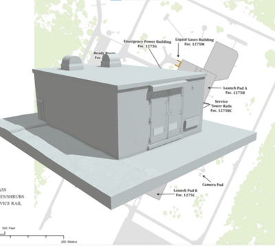
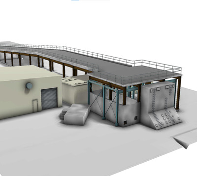
Facility 1275H Emergency Power at LC-26
Center for Digital Heritage and Geospatial Information
This structure is part of Launch Complex 26 at Cape Canaveral Space Force Station, Brevard County, Florida. The Emergency Power facility (1275H) was associated with the Pad B area (see basemap). This historic complex has served two primary functions – as a launch facility and as a museum. The LC-26 site was associated with the Redstone research and development program and later the Jupiter program. Additionally, the first American satellite, Explorer I, was famously launched from LC-26 on January 31, 1958. The site was a dual-pad, single blockhouse complex constructed in 1957, and was also used for several launch missions involving primates that preceded human space exploration missions. The complex is a significant cultural resource listed on the National Register of Historic Places (NRHP).
-

High Pressure Air Building
Center for Digital Heritage and Geospatial Information
The High Pressure Air Building (Fac. 2805) is a structure at the historic Launch Complex 3-4 at Cape Canaveral Space Force Station and was constructed in 1955 and functioned in that capacity until 1960. The complex was associated with the missile systems of the Bumper-WAC, Lark, Bomarc, X-17, Redstone, RV-A-10, , Polaris FTV, Matador, and Jason. Ideal CAD model derived from laser scanning measurements and documentation. 3D Animation to see building in relation to the LC 3-4 and Bomarc Building area https://vimeo.com/664834879
-

Historic Quonset Building
Center for Digital Heritage and Geospatial Information
Building 49800 at Cape Canaveral Space Force Station, Florida.
-

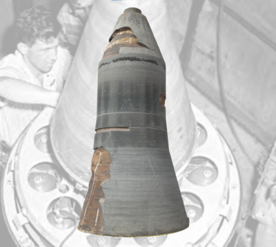
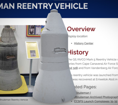
ICBM Thermonuclear Warhead Reentry Vehicle
Center for Digital Heritage and Geospatial Information
The Mark 5 Reentry vehicle was used on the LGM-30 Minuteman I & II ICBMs to protect its warhead as it reentered the atmosphere. The steel honeycomb structure has a quartz resin coating that burns away during reentry to dissipate the heat. Inside the reentry vehicle is a Type W59 thermonuclear warhead with a yield equivalent to one million tons of TNT. Test launches of Minuteman I missiles began in February 1961 at LC-31 on the Cape Canaveral Space Force Station. The first operational missiles came into service in October 1962. This Mark 5 was launched from Vandenberg AFB, California, in the early 1960’s as part of a test exercise. The piece was recovered from the target site at Eniwetok Atoll and given to the Air Force Space and Missile Museum in 1965 and is today on display at Cape Canaveral Space Force Station at the Sands Space History Center Museum just outside the south gate.
-

Inert Storage Magazine
Center for Digital Heritage and Geospatial Information
Facility 1322 is located on Patrick Space Force Station (PSFS), Brevard County, Florida. It was constructed in 1941 and is among the first structures at Banana River Naval Air Station (NAS) which later became PSFS. The structure is a raised one story rectangular block building, and is 1377 sq. ft. in size. It has a gable roof with corrugated asbestos square panels. There is a canopy for the loading dock area. The wall panels and foundation are all made from concrete, with a concrete ramp on the east end and stairs to west of the structure. Of note are the oversized steel doors in center on south side of the structure.
-

Interior Blockhouse 1 and 2, Cape Canaveral
Center for Digital Heritage and Geospatial Information
Blockhouse 1 & 2 was constructed in the early 1950s to oversee Snark winged missile program activities on Launch Pads 1 and 2. The blockhouse had four-inch thick, tempered laminated glass, and was connected underground to the pads by tunnels. Visual observations of the pads were made through a pair of mirrors that reflected images of through the tempered glass windows and downward to observers within the structure. The CDHGI at USF worked in collaboration with the Space Launch Delta 45 and the US Space Force to digitally document historic launch complexes at Cape Canaveral. 3D scanning, imaging, photogrammetry, GPS and GIS are allowing us to work on long-term preservation strategies, and helping us share these national treasures with the public.
-

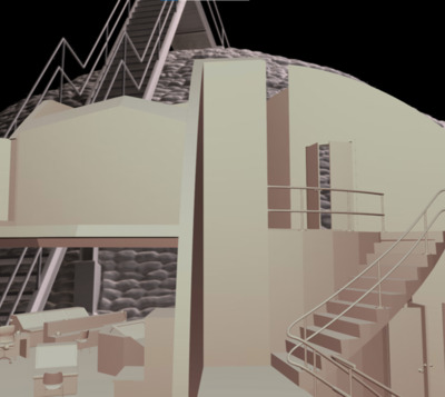
Interior of Blockhouse at Launch Complex 3 and 4
Center for Digital Heritage and Geospatial Information
This is the interior configuration of the blockhouse as derived from 1958 as-built drawings that were converted to 3D CAD as part of our historic preservation grant program with Cape Canaveral 45th Space Wing. The complex was constructed between 1950 and 1953, and was used throughout the 1950s including for the Bumper, Matador, Bomarc, Lark, X-17, Polaris FTV, and Redstone missile programs. Launch Complex 3 and 4 was considered to be technologically advanced for its time, and the facilities would later be modified for medical support area for the Mercury Project. The historic launch complexes at Cape Canaveral are being recorded using 3D and imaging technologies and a GIS survey approach as part of a historic preservation and documentation program partnership with University of South Florida researchers and the US Space Force.
-

Launch Complex 14 Ramp and Stamp
Center for Digital Heritage and Geospatial Information
Launch Complex 14 (BR2209), is an Historical District and National Historical Landmark. Shown here is a model of the ramp stand area at Cape Canaveral Air Force Station, documented with terrestrial laser scanning (TLS) survey that included the capture of the Blockhouse, ramp, stand, pad and surrounding environs and related structures. Launch Complex 14 was built between 1956 and 1957, and was most famously associated with the 1959 and 1960 manned Mercury missions.
