
Files
Download
Download Full Text (1.3 MB)
Preview
Creation Date
2011
Abstract
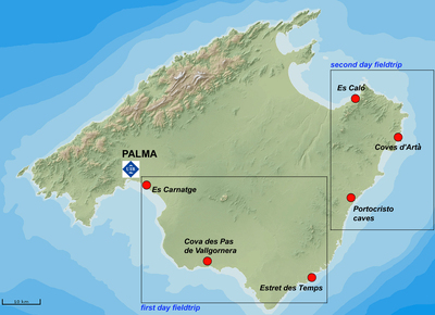
Map depicting locations for the fieldwork activities associated with the "Sea Level Change into MIS 5" workshop in Mallorca, Spain, 10-14 April 2012.
Alt Text
A map of the island of Mallorca, Spain, highlighting various locations with red dots and labeled destinations. The island's geography includes mountains and coastal areas, with Palma marked prominently.
Keywords
fieldwork map, Mallorca (Spain)
Identifier
Fieldwork Map, "Sea Level Change into MIS 5" Workshop, 10-14 April 2012
Recommended Citation
Onac, Bogdan P., "Fieldwork Map, "Sea Level Changes into MIS 5" Workshop" (2011). Environmental Sustainability Gallery. Image 6.
https://digitalcommons.usf.edu/tles_gallery/6
