
Monteverde Institute: Sustainable Design, Planning and Community Development
Alternative Title
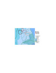
[Hydrology map: Los Llanos, Santa Elena, Cerro Plano y Monteverde]
Files
Download Full Text (101 KB)
Publication Date
January 2007
Abstract
Hydrology map includes the rivers Abangares, Acapulco, Aranjuecita, Guacimal, Lagarto, Peñas Blancas, San Luis, y Veracruz.
Resumen
Mapa hidrológico, incluye los ríos de Abangares, Acapulco, Aranjuecita, Guacimal, Lagarto, Peñas Blancas, San Luis y Veracruz.
Keywords
Rivers, Sustainable Futures 2007
Palabras claves
Futuros Sostenibles 2007
Extent
1 map
Geographic Location
Monteverde (Puntarenas, Costa Rica)
Language
Spanish
Media Type
Maps (Documents)
Format
Digital Only
Identifier
M37-00218
Creative Commons

This work is licensed under a Creative Commons Attribution-Noncommercial-No Derivative Works 3.0 License.
Recommended Citation
Monteverde Institute, "Mapa Hidrológico: Los Llanos, Santa Elena, Cerro Plano y Monteverde, 2007" (2007). Monteverde Institute: Sustainable Design, Planning and Community Development. 138.
https://digitalcommons.usf.edu/sustainable_futures/138
