
Stokes Collection of Florida Plant Railway Photographs
Alternative Title
Map of the Road
Files
Download Full Text (715 KB)
Preview
Creation Date
1-1-1893
Time Period
circa 1893-1895
Abstract
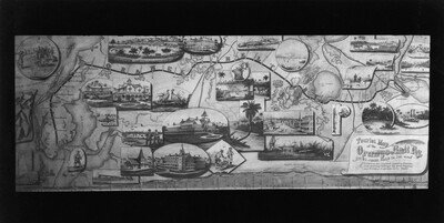
A tourist map of the Orange Belt Railroad. The label at the bottom right reads "Tourist Map of the Orange Belt Ry, Sportsman Route, St. Johns River to the Gulf" and "Crossing the highest Land in Florida, and passing through the best Hunting and Fishing regions in the State."
Alt Text
An illustrated map featuring various landmarks, ships, and buildings connected by roads and waterways. The map includes decorative elements and text along the borders.
Keywords
Roads, Railroads
Extent
1 black-and-white photograph
Physical Collection
Box
2
Language
English
Digital Date
2025
Media Type
Black-and-white photographs
Identifier
S54-091
Recommended Citation
Stokes, Charles H., "Tourist Map of the Orange Belt Railway, Sportsman's Route" (1893). Stokes Collection of Florida Plant Railway Photographs. Image 98.
https://digitalcommons.usf.edu/stokes/98
Keywords
Roads, Railroads
Rights Statement

