
Robert Porter Allen Papers - Photographs
Files
Download
Download Full Text (5.1 MB)
Preview
Creation Date
January 1950
Abstract
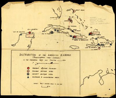
A map by Robert Porter Allen, depicting the distribution of the American Flamingo in the Caribbean.
Alt Text
A map showing the distribution of American flamingos in the Caribbean area and Yucatán Peninsula, with various marked locations and a legend explaining symbols used on the map.
Keywords
American flamingo, Bird populations, Estimates, Migration
Extent
1 map
Subject: geographic
Caribbean Area; Yucatán Peninsula
Physical Collection
Language
English
Media Type
Maps
Identifier
A55-00039
Recommended Citation
Allen, Robert Porter, "Map, Distribution of the American Flamingo In the Caribbean Area and Yucatan, 1950" (1950). Robert Porter Allen Papers - Photographs. Image 193.
https://digitalcommons.usf.edu/rpa_photographs/193
Keywords
American flamingo, Bird populations, Estimates, Migration
Rights Statement

