
Robert Porter Allen Papers - Photographs
Files
Download Full Text (6.1 MB)
Preview
Creation Date
January 1949
Abstract
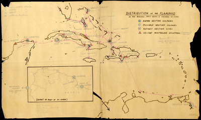
A map of the nesting colonies and recent wintering locations of the flamingo.
Alt Text
A map showing the distribution of flamingo nesting and wintering locations in the Caribbean region, with various marked sites and an inset map of Cuba. The map includes color-coded symbols indicating different types of flamingo habitats.
Keywords
Bird navigation, Bird populations, Estimates, Flamingos, Nests
Extent
1 map
Subject: geographic
Bahamas; West Indies; South America
Physical Collection
Language
English
Media Type
Maps
Identifier
A55-00038
Recommended Citation
Allen, Robert Porter, "Map, Distribution of the Flamingo In the Bahamas, West Indies, and Northern South America, 1949" (1949). Robert Porter Allen Papers - Photographs. Image 192.
https://digitalcommons.usf.edu/rpa_photographs/192
Keywords
Bird navigation, Bird populations, Estimates, Flamingos, Nests
Rights Statement

