
Roberts City Collection - Images
Files
Download Full Text (127.3 MB)
Preview
Creation Date
1980
Time Period
circa 1980
Abstract
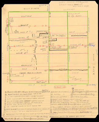
Hand-drawn map of Roberts City from 1917 to 1960. The boundary of the neighborhood is the Hillsborough River to the north, North Boulevard to the west, Cass Street to the south, and the Hillsborough River to the east. Included are notations of businesses and places of interest within the neighborhood.
Alt Text
A hand-drawn map with labeled streets and landmarks, surrounded by notes and annotations on a piece of paper. The map includes various symbols and markings indicating different locations and points of interest.
Extent
1 hand-drawn map
Subject: geographic
Hillsborough County (Fla.); Tampa (Fla.); Roberts City (Tampa, Fla.)
Physical Collection
Box
3
Language
English
Digital Date
2023
Media Type
Maps
Identifier
roberts_city_photos_1018
Recommended Citation
Lopez, George, "Map, Hand-drawn of Roberts City, circa 1980" (1980). Roberts City Collection - Images. Image 19.
https://digitalcommons.usf.edu/roberts_city_photos/19
Image Location
Latitude
27.95314
Longitude
-82.46699
Rights Statement

