
Binder 04: Photographs and Images
Alternative Title
McRoy Miskito Bank - Map
Files
Download Full Text (1.9 MB)
Preview
Creation Date
5-1-1983
Abstract
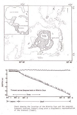
Map showing the location of the Miskito Cays, Nicaragua and the seagrass transect stations (upper) along with a diagrammatic representation of the transects (lower). The Miskito Cays were the location of the research expedition of Dr. John C. Ogden and his colleagues to Miskito Bank, Nicaragua aboard the R/V [Research Vessel] Alpha Helix from October 13, 1977 to November 18, 1977 where their research included studies on seagrasses, fish, sea urchins, and the green sea turtle (Chelonia mydas). To study the seagrass around the Miskito Cays, researchers did multiple transects. A transect is a research method used in ecology where a researcher lays out a line of a certain distance across a habitat with regular intervals marked on the line. The researcher then observes and records the number of occurrences of the object of study (such as a particular species of seagrass) at each regular interval on the transect line. The top image shows a map of the seagrass transect locations (MT-1 through MT-5) while the bottom image shows a diagram of what depth each seagrass transect was at, with transects MT-1 and MT-2 being at the shallow lagoon while transect MT-3 through MT-5 were at the deeper continental shelf.
Alt Text
A map showing the location of the Miskito Cays and a seagrass transect, with depth measurements indicated on a separate graph below. The map includes geographical coordinates and labels for various features.
Keywords
Marine biology--Research, Miskito Coast (Nicaragua and Honduras), Maps, Ecological surveys, Seagrasses
Extent
2 x 2 inches plastic projector slide with 35mm color photographic film
Physical Collection
Language
English
Digital Date
2023
Media Type
Color slides
Identifier
O19-00085
Recommended Citation
Ogden, John C. and McRoy, Peter, "Map of the Miskito Cays, Nicaragua and diagram of seagrass surveys" (1983). Binder 04: Photographs and Images. Image 1.
https://digitalcommons.usf.edu/ogden_images/1
Keywords
Marine biology--Research, Miskito Coast (Nicaragua and Honduras), Maps, Ecological surveys, Seagrasses
Image Location
Latitude
14.338333
Longitude
-82.77
Rights Statement

