
Binder 09: Photographs and Images
Files
Download Full Text (2.8 MB)
Preview
Creation Date
1971
Abstract
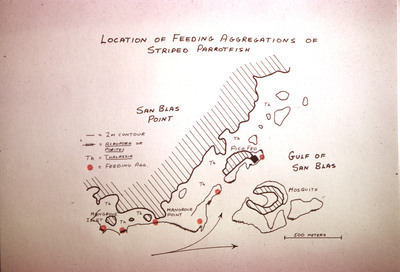
A map titled "Location of Feeding Aggregations of Striped Parrotfish". The map shows areas of the San Blas archipelago of Panama where striped parrotfish (Scarus iseri, formerly known as Scarus croicensis) were observed feeding in large groups. Also marked on the map are locations of seagrass of Genus Thalassia and corals of Genus Acropora and Genus Porites.
Alt Text
A hand-drawn map showing the "Location of Feeding Aggregations of Striped Parrotfish," with labeled points and areas. The map includes San Blas Point, Gulf of San Blas, and Mosquito, with a scale indicating 500 meters.
Keywords
Marine biology--Research, Coral reef ecology, Maps, Parrotfishes, Acropora, Porites, Seagrasses
Extent
2x2 projector slide
Physical Collection
Box
4
Folder
Binder 9
Language
English
Digital Date
2023
Media Type
Color slides
Identifier
O19-00359
Recommended Citation
Ogden, John C., "Slide, Location of Feeding Aggregations of Striped Parrotfish, 1971" (1971). Binder 09: Photographs and Images. Image 160.
https://digitalcommons.usf.edu/ogden9_images/160
Keywords
Marine biology--Research, Coral reef ecology, Maps, Parrotfishes, Acropora, Porites, Seagrasses
Image Location
Latitude
9.555493
Longitude
-78.966145
Rights Statement

