
Binder 06: Photographs and Images
Files
Download
Download Full Text (58.3 MB)
Preview
Creation Date
1-30-1981
Abstract
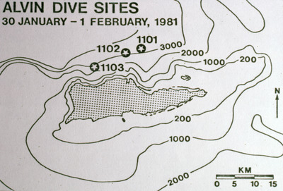
A map of dive sites 1101, 1102, and 1103 of research submersible ALVIN on January 30, 1981, in Christiansted Submarine Canyon.
Alt Text
A map showing dive sites labeled with numbers and dates from January 30 to February 1, 1981. The map includes depth contours and a scale for distance measurement, with all details in black and white.
Keywords
Marine science, Oceanography, Field scientists, Coral reefs
Extent
1 color photograph
Subject: geographic
United States Virgin Islands, Caribbean Area
Physical Collection
Folder
Binder 6
Digital Date
2024
Media Type
Color photographs
Identifier
O19-03193
Recommended Citation
Ogden, John C., "Map, ALVIN Dive Sites, January 30-February 1, 1981" (1981). Binder 06: Photographs and Images. Image 45.
https://digitalcommons.usf.edu/ogden6_images/45
Keywords
Marine science, Oceanography, Field scientists, Coral reefs
