
Binder 01: Photographs and Images
Files
Download
Download Full Text (3.1 MB)
Preview
Creation Date
11-4-1980
Abstract
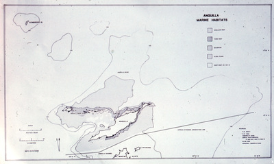
A map of marine habitats in the British Overseas Territory of Anguilla used during a trip to the region on November 4-7, 1980.
Alt Text
A map of Anguilla's marine habitats with various zones marked and labeled. The legend indicates different habitat types such as seagrass beds, coral reefs, and mangroves.
Keywords
Coral reefs and islands, Reef ecology, Marine sciences, Travel
Extent
1 black-and-white photograph of a map
Physical Collection
Box
1
Folder
Binder 1
Digital Date
2024
Media Type
Black-and-white photographs; Maps
Identifier
O19-01902
Recommended Citation
Ogden, John C., "Map of Marine Habitats in Anguilla, November 4-7, 1980" (1980). Binder 01: Photographs and Images. Image 166.
https://digitalcommons.usf.edu/ogden1_images/166
Keywords
Coral reefs and islands, Reef ecology, Marine sciences, Travel
Image Location
Latitude
18.227220
Longitude
-63.048890
Rights Statement

