
Binder 19: Photographs and Images
Files
Download Full Text (4.6 MB)
Preview
Creation Date
1-1-1991
Abstract
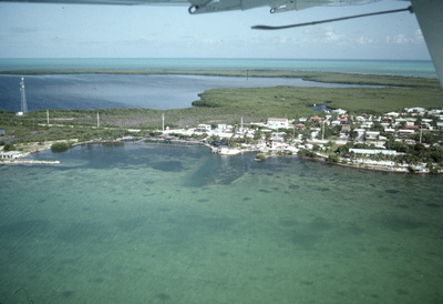
An aerial view from a plane shows land, water, and buildings of Dry Tortugas, Florida. This photograph was taken during a Sustained Ecological Research Related to Management of the Florida Keys Seascape (SEAKEYS) expedition.
Alt Text
Aerial view of a coastal town with clear turquoise waters and lush green land. Buildings, roadways, and utility poles are present on the shore, with the dense vegetation expending in the background of the island. The horizon shows the ocean meeting the sky.
Keywords
Marine science, Oceanography, Field scientists, Marine ecology, Coral reefs, Sustained Ecological Research Related to Management of the Florida Keys Seascape (SEAKEYS)
Extent
1 aerial photograph
Physical Collection
Box
7
Folder
Binder 19
Digital Date
2024
Media Type
Aerial photographs
Identifier
O19-02823
Recommended Citation
Porter, James W., "Aerial of Dry Tortugas, Florida" (1991). Binder 19: Photographs and Images. Image 4.
https://digitalcommons.usf.edu/ogden19_images/4
Keywords
Marine science, Oceanography, Field scientists, Marine ecology, Coral reefs, Sustained Ecological Research Related to Management of the Florida Keys Seascape (SEAKEYS)
Image Location
Latitude
24.66596929
Longitude
-82.85544137
Rights Statement

