
Binder 18: Photographs and Images
Files
Download
Download Full Text (4.6 MB)
Preview
Creation Date
1995
Time Period
circa 1990s
Abstract
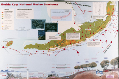
A map showing the distribution of the different currents of the Florida Keys National Marine Sanctuary
Alt Text
A detailed map of the Florida Keys National Marine Sanctuary with various labeled areas and features. The map includes a legend, images, and annotations about habitats, ocean currents, and the path of Hurricane Andrew, a Category 5 storm that hit the Florida peninsula in 1992.
Keywords
Maps, Currents
Extent
1 color photograph
Physical Collection
Box
6
Folder
Binder 18
Digital Date
2024
Media Type
Color photographs
Identifier
O19-02806
Recommended Citation
Ogden, John C., "Map of Currents of Florida Keys National Marine Sanctuary" (1995). Binder 18: Photographs and Images. Image 380.
https://digitalcommons.usf.edu/ogden18_images/380
Keywords
Maps, Currents
Rights Statement

